
Our planet faces unprecedented environmental challenges, yet technology offers hope through groundbreaking satellite imaging innovations. These orbital observers are revolutionizing how we understand, monitor, and combat climate change.
For decades, scientists have struggled to obtain comprehensive, real-time data about Earth’s changing climate patterns. Traditional ground-based monitoring systems, while valuable, provide only fragmented glimpses of our planet’s complex environmental systems. Satellite imaging technology has transformed this landscape entirely, offering a bird’s-eye view that captures climate dynamics on scales previously unimaginable. From melting ice caps to deforestation patterns, these space-based instruments deliver critical intelligence that drives actionable climate solutions.
🛰️ The Evolution of Earth Observation Technology
Satellite imaging has come a long way since the first weather satellites launched in the 1960s. Early systems captured grainy black-and-white images with limited resolution, providing basic cloud cover information. Today’s advanced satellites employ sophisticated sensors capable of detecting minute changes in temperature, vegetation health, sea levels, and atmospheric composition with remarkable precision.
Modern Earth observation satellites operate across multiple spectral bands, from visible light to infrared and microwave frequencies. This multi-spectral capability allows scientists to penetrate cloud cover, measure surface temperatures, track moisture levels, and identify specific gases in the atmosphere. The European Space Agency’s Sentinel satellites, NASA’s Landsat program, and numerous commercial providers now maintain a constellation of sensors constantly monitoring our planet’s vital signs.
Resolution Revolution: Seeing Earth in Unprecedented Detail
The spatial resolution of satellite imagery has improved dramatically, with some commercial satellites now achieving sub-meter accuracy. This means researchers can distinguish individual trees, track small-scale agricultural changes, and monitor urban development with extraordinary clarity. Temporal resolution has also advanced significantly, with some satellites revisiting the same location multiple times daily, enabling near-real-time environmental monitoring.
Hyperspectral imaging represents another breakthrough, capturing data across hundreds of narrow spectral bands rather than just a few broad ones. This technology functions like giving satellites “super vision,” detecting subtle environmental changes invisible to conventional cameras. Scientists can now identify specific plant species, measure water quality parameters, detect soil composition, and even identify mineral deposits from space.
🌍 Mapping Climate Change Impacts Across the Globe
Satellite imaging provides irrefutable visual evidence of climate change impacts worldwide. These orbital witnesses document environmental transformations that might otherwise go unnoticed or disputed, creating a comprehensive archive of our planet’s changing face.
Arctic and Antarctic Ice Loss Documentation
Polar regions serve as Earth’s climate canaries, and satellites monitor their declining ice coverage with alarming precision. NASA’s ICESat-2 mission uses laser altimetry to measure ice sheet thickness changes down to centimeters. The data reveals accelerating ice loss in Greenland and Antarctica, contributing to rising sea levels that threaten coastal communities globally.
Satellite synthetic aperture radar (SAR) penetrates clouds and darkness, providing continuous monitoring regardless of weather conditions or polar night. These measurements show Arctic sea ice declining at approximately 13% per decade, fundamentally altering ocean circulation patterns, wildlife habitats, and indigenous communities’ traditional ways of life.
Deforestation Detection and Forest Health Monitoring
Tropical forests absorb massive quantities of atmospheric carbon dioxide, making their preservation critical for climate stability. Satellite imaging systems now detect illegal logging activities within days, enabling rapid response from environmental authorities. Global Forest Watch, powered by satellite data, provides free, near-real-time information about forest changes worldwide.
Beyond simple deforestation detection, modern satellites assess forest health by measuring chlorophyll content, water stress, and disease outbreaks. This information helps forest managers implement targeted interventions before minor problems become catastrophic losses. Researchers also use satellite data to calculate forest carbon storage capacity, essential for understanding global carbon cycles and validating carbon offset programs.
🔥 Early Warning Systems for Environmental Disasters
Satellite technology has revolutionized disaster prediction and response, providing crucial lead time that saves lives and reduces economic losses. These systems transform raw orbital data into actionable intelligence for emergency managers and affected communities.
Wildfire Detection and Prediction
Climate change has intensified wildfire seasons across multiple continents. Satellites equipped with thermal sensors detect heat signatures from fires often before ground observers notice them. NASA’s MODIS and VIIRS instruments scan for thermal anomalies twice daily, identifying fire locations and estimating their intensity and spread direction.
Advanced algorithms combine satellite data with weather forecasts, topography, and vegetation moisture levels to predict fire behavior and identify high-risk areas before ignition occurs. This predictive capability allows firefighting resources to be pre-positioned strategically, potentially preventing small fires from becoming catastrophic conflagrations.
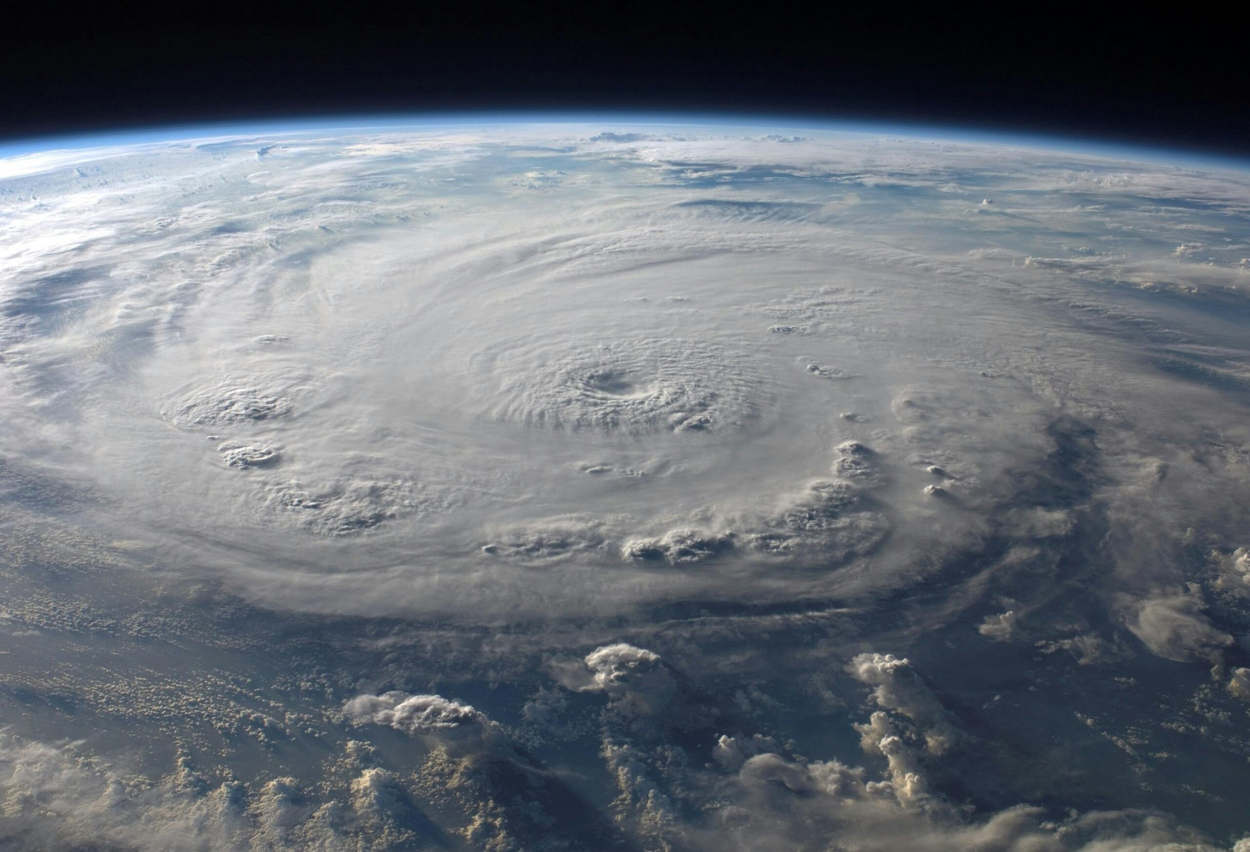
Hurricane Intensity and Flood Monitoring
Warming ocean temperatures fuel stronger hurricanes, and satellites provide the only practical means of monitoring these massive storm systems across open oceans. Microwave sensors measure sea surface temperatures, wind speeds, and atmospheric moisture content—critical inputs for hurricane intensity forecasting models.
During flood events, SAR satellites penetrate clouds to map inundation extent even during active storms. Emergency responders use these flood maps to prioritize rescue operations and assess infrastructure damage. After disasters, satellite imagery documents destruction extent, accelerating insurance claims and recovery funding distribution.
🌾 Agricultural Optimization Through Precision Monitoring
Agriculture contributes significantly to greenhouse gas emissions while simultaneously facing mounting climate change pressures. Satellite imaging drives precision agriculture practices that reduce environmental impact while maintaining food security for growing populations.
Crop Health Assessment and Yield Prediction
Multispectral satellite imagery reveals crop health variations invisible to human eyes. The Normalized Difference Vegetation Index (NDVI) and similar metrics calculated from satellite data indicate photosynthetic activity, water stress, nutrient deficiencies, and disease presence. Farmers receive field-specific recommendations, applying inputs only where needed rather than uniformly treating entire fields.
This precision approach reduces fertilizer runoff that contributes to water pollution and greenhouse gas emissions. It also decreases pesticide usage, protecting beneficial insects and reducing agricultural’s chemical footprint. Satellite-based yield predictions help commodity markets function more efficiently and enable governments to anticipate food security challenges months in advance.
Water Resource Management in Agriculture
Agriculture consumes approximately 70% of global freshwater resources, making efficient irrigation critical as climate change disrupts precipitation patterns. Satellites measure soil moisture, evapotranspiration rates, and irrigation system performance across vast agricultural regions.
Farmers use this information to optimize irrigation timing and volume, conserving water while maintaining crop productivity. Regional water authorities employ satellite data to detect illegal water extraction, monitor reservoir levels, and allocate scarce water resources equitably during drought conditions.
🏙️ Urban Heat Islands and Sustainable City Planning
Cities concentrate both population and climate change impacts. Urban heat islands—where built environments trap heat—intensify heatwave dangers and increase cooling energy demands. Satellite thermal imaging maps these heat patterns with neighborhood-level precision.
Urban planners use satellite data to identify heat hotspots requiring intervention through green infrastructure, reflective surfaces, or increased tree canopy. Time-series satellite analysis reveals how development patterns affect local temperatures, informing zoning decisions and building codes that prioritize climate resilience.
Satellite measurements of urban air quality complement ground sensors, providing comprehensive pollution monitoring that protects public health. Nitrogen dioxide, particulate matter, and other pollutants appear distinctly in satellite imagery, enabling authorities to identify emission sources and verify pollution reduction measures’ effectiveness.
🌊 Ocean Monitoring: The Final Frontier
Oceans cover 71% of Earth’s surface and absorb approximately 90% of excess heat from greenhouse gas emissions. Satellite ocean monitoring reveals critical climate change indicators while remaining largely invisible to land-based observers.
Sea Level Rise Measurement
Radar altimetry satellites measure sea surface height with millimeter precision, documenting global sea level rise currently occurring at approximately 3.4 millimeters annually. This seemingly small change translates to enormous consequences for coastal communities, saltwater intrusion into freshwater aquifers, and increased storm surge flooding.
Satellite measurements reveal that sea level rise varies regionally due to ocean currents, gravitational effects from ice loss, and thermal expansion differences. This spatial detail helps coastal planners understand their specific vulnerabilities and design appropriate adaptation strategies.
Ocean Temperature and Acidification Indicators
Satellite sea surface temperature measurements track marine heatwaves that devastate coral reefs and disrupt fisheries. These extreme temperature events have become more frequent and intense as climate change progresses, with satellites providing the only practical monitoring system across vast ocean expanses.
While satellites cannot directly measure ocean acidification, they track phytoplankton populations and ocean color changes that indicate ecosystem stress from increasing carbon dioxide absorption. Combined with ocean buoy data, satellite observations help scientists understand how acidification threatens marine food webs from tiny plankton to commercial fisheries.
💡 Artificial Intelligence Amplifying Satellite Data Value
The volume of satellite data now exceeds human capacity for manual analysis. Modern Earth observation satellites generate petabytes of information annually—far more than traditional analysis methods can process. Artificial intelligence and machine learning algorithms unlock this data treasure, identifying patterns and extracting insights at unprecedented speed and scale.
Deep learning models trained on millions of satellite images automatically detect and classify features like buildings, roads, crops, and water bodies. These algorithms identify subtle changes over time that human analysts might miss, such as gradual vegetation shifts indicating ecosystem stress or early-stage invasive species encroachment.
Automated Change Detection for Rapid Response
AI-powered systems continuously analyze new satellite imagery, automatically flagging significant changes for human review. Deforestation alerts, unauthorized construction in protected areas, oil spills, and methane leaks from energy infrastructure now trigger notifications within hours of detection rather than weeks or months later.
This rapid detection capability transforms enforcement of environmental regulations and climate commitments. Governments and NGOs can respond to violations while evidence remains fresh and interventions prove most effective. The psychological deterrent effect of knowing satellites are watching also encourages compliance with environmental protections.
🤝 Democratizing Climate Data Access
Historically, satellite imagery remained expensive and accessible primarily to governments and large research institutions. This paradigm has shifted dramatically, with numerous platforms now providing free or low-cost access to satellite climate data for researchers, journalists, activists, and citizens worldwide.
Google Earth Engine offers cloud-based analysis of the entire Landsat and Sentinel satellite archives—decades of imagery available for analysis without expensive software or computing infrastructure. NASA’s Earthdata portal provides free access to hundreds of Earth observation datasets. The European Space Agency’s Copernicus program operates on an open data philosophy, making Sentinel satellite data freely available globally.
This democratization empowers local communities to monitor environmental changes affecting their regions, hold polluters accountable, and participate meaningfully in climate adaptation planning. Indigenous communities use satellite data to document traditional territory changes and support land rights claims. Journalists employ satellite analysis to investigate environmental crimes and government climate commitments.
🔮 Future Innovations on the Horizon
The satellite imaging revolution continues accelerating, with emerging technologies promising even more powerful climate change solutions. Small satellite constellations consisting of hundreds of coordinated spacecraft will provide hourly updates rather than daily or weekly revisits, capturing dynamic processes like storm development and pollution plume dispersion in unprecedented detail.
Advanced sensor technologies under development include atmospheric lidar systems that profile greenhouse gas concentrations throughout the atmosphere’s vertical structure, laser fluorescence sensors that measure plant photosynthetic efficiency, and quantum sensors offering orders of magnitude improvement in measurement sensitivity.
Carbon Monitoring from Space
Perhaps the most significant emerging capability involves direct greenhouse gas measurement from space. NASA’s recently launched Earth System Observatory and similar missions from other space agencies will map carbon dioxide and methane emissions with source-level attribution. This technology will verify national emissions reports, identify super-emitter facilities, and track progress toward Paris Agreement targets with unprecedented accountability.
These carbon-monitoring satellites will transform climate policy from self-reported estimates to independently verified measurements, fundamentally changing international climate negotiations and carbon market operations. Companies claiming carbon neutrality will face satellite verification, while countries can identify emission reduction opportunities based on comprehensive spatial data.
🌟 Transforming Data into Climate Action
Satellite imaging technology provides extraordinary climate insights, but data alone does not solve problems. The true potential unlocks when satellite information drives concrete actions—policy changes, investment decisions, behavioral shifts, and technological innovations that reduce emissions and build climate resilience.
Success stories demonstrate this transformation in action. Indonesia reduced deforestation rates significantly after implementing satellite-based forest monitoring systems. California’s wildfire response improved dramatically through satellite early warning integration. Pacific island nations use satellite sea level data to advocate for climate action in international forums. Farmers worldwide optimize resource use based on satellite-derived agricultural intelligence.
The coming decades will determine humanity’s success in addressing climate change. Satellite imaging innovations provide essential tools for this challenge—revealing problems that demand attention, monitoring solutions’ effectiveness, and holding nations and corporations accountable for climate commitments. These orbital observers function as Earth’s diagnostic instruments, helping us understand our planet’s health and prescribe appropriate treatments.
As satellite technology continues advancing and data access democratizes further, more people gain the power to contribute to climate solutions. From scientists developing global climate models to farmers optimizing water use to activists documenting environmental destruction, satellite imaging empowers diverse stakeholders with common cause: protecting our planet’s future. The view from space reveals both the fragility of Earth’s climate systems and the immense human capacity for innovation and adaptation when armed with knowledge and determination. 🌎